Checkpoint 5
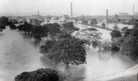
Peel Park flood
The photo shows a flooded Peel Park, the flood water at a depth of more than four feet.
Some facts relating to the photo
The photo was taken in 1946. The worst recorded flooding happened 80 years earlier, in 1866, when the flood water reached heights of more than eight feet. This event is marked by the flood obelisk that is found in the Park.
Peel Park opened in 1846. It was one of the first public parks to open in the UK at a time when other parks were privately owned.
The Park was used to film scenes for the Bafta-winning film, Hobson's Choice, in the early 1950s. Hobson’s Choice was originally a play written by the Eccles-born playwright, Harold Brighouse, and was set largely around Chapel Street, Salford.